
Hiking Colombia’s Valle de Cocora, the site of the world’s tallest palm trees
- Cecilia Markley
- 2 days ago
- 10 min read

Marijn and I made a thorough itinerary before beginning our backpacking journey through South America. We agreed we didn’t have to stick to it exactly, but we wanted to know where we were going, what we would do and how much time we would spend in each place, how much to budget, and how to get from each location to the next. Salento was not on the itinerary at all for Colombia.
Why not, you might be asking. Well, this was Marijn’s second time in the country. He was here in 2023 with his family. They went to Salento when they came, but they did not go to San Gil. When making our itinerary, he thought San Gil would be a less touristy substitute for Salento, so if we did San Gil, we didn’t need to do Salento. But after talking to some backpackers in San Gil who had already gone to Salento, we decided to add it to the itinerary between Medellin and Bogotá, and I am so glad we did!
Salento, Colombia


Salento is a small town of about 10,000 in the Andes Mountains west of the capital Bogotá. The town’s elevation is around 6,230 feet (1,900 meters) above sea level. Located in Colombia’s ‘coffee triangle region,’ it is a great place to do a coffee tour. We took advantage of this with a tour of a local finca, or coffee farm, arranged by our hostel, for COP50,000 (approx. $13.50) each.
Salento is definitely touristy. Nearly everyone on the public bus we took from Medellin was a fellow backpacker. The big reason for the town being such a popular tourist destination is that it is just a short drive from arguably the most popular attraction in the area, Valle de Cocora, or Cocora Valley in English.
Valle de Cocora

The Quindío wax palm, Colombia’s national tree, is found only in the Andes Mountains of Colombia and Peru and can grow as tall as 200 feet (60 meters)! Despite their popularity and beauty, they are sadly critically endangered due to habitat disturbance and overharvesting by humans, as well as disease. Valle de Cocora has 1,000–2,000 wax palms, and seeing the towering trees in person was definitely incredible.
The 5-hour loop hike

When visiting Valle de Cocora, there are typically three options for how to tackle the park. The first is to go straight when you get dropped off, heading directly to the park entrance and paying the entry fee of COP30,000 (approx. $8) each. From here, you can walk directly to the viewpoint overlooking the valley. You can then choose to either 1) continue on and do the ‘5-hour loop hike,’ as it is often called, or 2) head back after seeing the valley in all its glory.
The third option is to go right before the park entrance and begin walking down a hill. This is often called the ‘counter-clockwise loop.’ This is the hike Marijn did when he came to Cocora with his family three years ago, and it is the hike we planned to do. Both loop hikes take you around the entirety of the valley and are 6.8–7.5 miles (11–12 kilometers).
Both the clockwise and counter-clockwise are good options, but our research, and Marijn’s experience, told us that the counter-clockwise is cooler if you want to end on a high note. If you go counter-clockwise, you end at the viewpoint overlooking the valley, whereas with the clockwise loop, you start in the valley.
We wanted to end in the valley, passing through cloud forest and beautiful landscapes on the way. Marijn said the hike is easy to moderate and, while only at the end do you emerge in the valley filled with wax palms, you still see them along the way, as well as plenty of other nature.
Heavy rains the day before
We awoke at 6 a.m. the day we planned to go to Cocora to pouring rain. We consulted with our hostel, and they said we should definitely wait a day as not only would it not be fun to see the valley when it was raining, but it might not even be safe.
We spent the morning in, and once the rain cleared in the afternoon, we were able to go on the coffee tour. Before we left for the tour, the owner of the hostel showed us a video of the river at Cocora overflowing that morning due to all the rain. We were happy we had decided not to go.
Taking a ‘Willy’ to the valley

We befriended a woman in our hostel from France who joined us when we went the next day, and we walked to the Plaza de Bolívar in the center of town and bought our round-trip tickets to the park for COP12,000 (approx. $3.25) each. From Salento, the best way to get to Valle de Cocora is by catching a Willy.
Willys are Jeeps that have been modified to fit more people: three in the front, eight in the back, and three or four more standing on the back of the vehicle holding on. We sat in the back, where we befriended a woman from Mexico who also joined us for our adventure that day.
Starting the counter-clockwise hike
Around 20 minutes after leaving Salento, we arrived to the valley around 8 a.m. (it is recommended to get to the park early to avoid crowds and rain). Upon arrival, the view was already gorgeous. Just from pulling into the park, I could see the tall palm trees popping up out of rolling hills. After getting off the Willy, the four of us headed right and walked down a paved road to begin the 5-hour counter-clockwise hike.
Getting turned around
We knew that on the 5-hour hike it is required to pay a fee to walk through a local finca’s property. After about five minutes walking downhill, we encountered a family with two young children walking up. They told us that they were turned around when they arrived at the entrance of the finca because the rain from the day before had caused a landslide further along on the trail, and it was not safe to cross yet. The man at the finca had told them to do the clockwise loop, explaining that they hoped to have the path cleared in a few hours, and it would be safe to cross by the time people doing the clockwise loop arrived.
We thanked them for the information and turned around. As we reached the top, we encountered a guide leading a group. We asked him about the situation, and he told us we were okay to go counter-clockwise, so we can head back down the way we came.
Alright, great news! We can do the hike we originally planned! We turned around and walked down to the entrance of the finca, about a 10-minute walk from the starting point. Upon arrival, the man at the finca told us the same information as he had told the family. We looked to the guide who had said we could go this way, and he responded that he was allowed to go because he was a guide, but we weren’t allowed.
Extremely frustrated at this point, we turned around for a second time and walked back up to the starting point. From here, we checked with a park employee and were directed to the entrance straight ahead. The four of us went to the park entrance and bought tickets for COP30,000 (approx. $8) each. From the entrance, it was a 30-minute walk uphill to the main viewpoint.
Reaching the valley viewpoint

The viewpoint was magnificent. From the platform where we stood and could buy coffee and snacks, we looked down over the valley with hundreds of palms so tall their roots started below us and the tops of them soared way above our heads. When we arrived, we took photos and relaxed for a while before huddling up to decide what to do next.
We spoke to three park employees, but they all gave us conflicting information on whether we could continue on this way to do the clockwise loop or not. The French woman from our hostel opted not to continue on the hike as she would be going on a trek the next day, but Marijn, the Mexican woman and I wanted to do the full hike. It was just a matter of if we could.
One guide at the viewpoint said we could go on, but there was no guarantee the landslide would be cleaned up by the time we arrived, and we may have to turn back. This would mean walking almost four hours to the landslide and potentially having to turn back around to walk back if we couldn’t pass.
Starting the hike again

We decided to take our chances doing the full hike, clockwise instead of counter-clockwise, as all three of us wanted to get the complete experience at Cocora. So, three hours after we had arrived and started the counter-clockwise hike, we began the clockwise hike from the viewpoint. We figured it would take us about four more hours from here, expecting to be done by around 3 p.m. We could not have predicted the confusion that was to come.
Pine trees, mountains, rivers and cloud forest


From the viewpoint, the next 45 minutes or so were uphill, during which time we passed several more beautiful viewpoints overlooking the valley. At one of those viewpoints, you can stop at a booth for snacks. We got some mango and sat enjoying the view before carrying on. We walked on until the trail flattened out and the landscape transformed into colossal pine trees.
We walked through the pine trees for 2o minutes until we emerged at the highpoint of the hike on one of the mountains that surrounds the valley. From here we could see mountains going on for what seemed like miles, all kissing the clouds.
At this point, it wasn’t even 1 p.m., and we were already beginning the descent down the mountain to the other side of the valley, so it seemed we were making good time. We walked down the mountain for less than 30 minutes before reaching a river, where the trail began to get crowded.
It seemed the hikers going in the opposite direction –heading up the mountain – were coming from upriver, so along the way, we stopped several groups to ask them where they were coming from and which loop they were doing. We wanted to know if the groups were going counter-clockwise and if they had already passed the finca and the landslide. No one we asked seemed certain which loop they were doing or if they had already paid the toll at the finca, but we decided that since everyone was coming from upriver, we should go that direction.
We began walking upriver for about 30 minutes on a slight incline, surrounded by cloud-forest vegetation. But something else strange was happening: people were turning around. Some of the hikers who had been in front of us heading down the mountain walked past us. When we asked people why, they said they were lost and had to turn around to head back to the valley viewpoint.
But we didn’t want to turn around. We were determined to keep going.
Whoops, we’re lost again

We carried on walking for a while until we arrived at an intersection. We opted to go left, and five minutes later we were in front of Acaime, the hummingbird house we had heard about that you can enter for an extra fee. But at this point, it was after 2 p.m., we had been there for six hours, and we just wanted to make sure we weren’t completely lost.
We stood dumbfounded outside the entrance to Acaime, unsure what to do at this point as it was just the three of us. A group at one point came, but they seemed just as lost as we did, and they entered the hummingbird house. Finally, we encountered another guide, who told us that our mistake had been going upriver instead of down. We would need to walk back to where we first met the river and follow it down.
The first helpful piece of advice we had received all day! We walked back to the river and followed it down, crossing bridge after bridge over the little river as it got bigger, letting it guide us down the mountain until we finally reached an opening in the vegetation.
Reaching the landslide


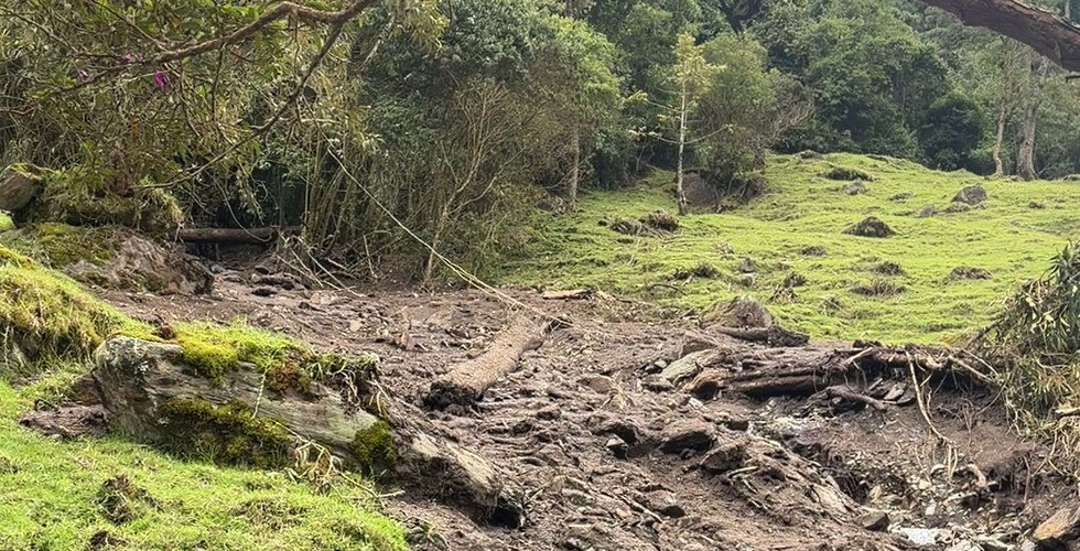
We emerged from the forested mountain onto flatter terrain at nearly 3 p.m. From here, it was a straight shot to the entrance of the finca and the conclusion of our hike. We just had to pass the landslide. We held our breath that we would be able to cross.
A few minutes later, we reached the landslide. It was clear that a lot of damage had been done. Trees were uprooted and destroyed, rocks were everywhere, and it was apparent that a strong current of water had ripped through the area. But by the time we arrived, the part of the landslide that crossed over the trail was cleared enough for an easy crossing and the water was down to a stream. There were workers continuing to clear the debris as we passed through.
Finishing the hike


The rest of the hike was through the coffee finca on flat terrain. We passed by some cows grazing, and one made direct eye contact with me, which was very cute. We stopped along the way for final photos and reached the entrance to the finca before 4 p.m. Here we paid COP 10,000 (approx. $2.70) each and headed up the hill we had begun our day walking down.
We arrived back at the main entrance shortly after 4 p.m., eight hours after we arrived for what we thought would be a five-hour hike. We treated ourselves to an early dinner at the park’s restaurant, which serves fresh trout, before heading back to town on a Willy.
While it may have been a longer and slightly more frustrating day than expected, it was absolutely worth the trouble to get to see the incredible valley. I definitely recommend going and doing the 5-hour loop hike, as you get to see not only the valley but also the cloud forest, pine trees and incredible mountains. We just happened to get unlucky that we went the day after a landslide. But the hike itself was still fun, albeit longer than anticipated. Valle de Cocora is near the top of my list for beautiful nature I got to see in Colombia.